NC1D
From SCECpedia
Jump to navigationJump to searchThis page documents the NC1D velocity model, created as part of the preparations for Study 24.6.
Summary
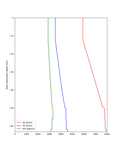
This model was created by creating a 1D representation of the (unmodified) Sierra gabbro region in SFCVM v22.1. It is intended for use in the northeastern parts of California, a region covered by few CVMs. It was created by extracting a 1D profile from the Sierra gabbro region and then manually creating a 1D model which closely approximates this profile. Note that the Sierra gabbro region as specified in SFCVM v22.1 has high near surface velocities (around 3500 m/s), so this is reflected in NC1D as well.
Contents
A UCVM-formatted configuration file specifying this model is available here. The layers specified in the model are:
| Layer thickness (km) | Vp (km/s) | Vs(km/s) | Density (gm/cm3) | Qp | Qs |
|---|---|---|---|---|---|
| 8.8990 | 5.9000 | 3.5025 | 2.8797 | 350.2500 | 175.1250 |
| 0.0010 | 5.9000 | 3.5025 | 2.8797 | 350.2500 | 175.1250 |
| 5.4200 | 6.2024 | 3.6414 | 2.9335 | 364.1400 | 182.0700 |
| 9.5200 | 6.7352 | 3.8763 | 3.0381 | 387.6300 | 193.8150 |
| 6.1600 | 7.0800 | 4.0367 | 3.1116 | 403.6700 | 201.8350 |
| 9.6000 | 7.6173 | 4.3354 | 3.2327 | 433.5400 | 216.7700 |
| 0.2700 | 7.7511 | 4.4031 | 3.2840 | 440.3100 | 220.1550 |
| 0.2650 | 7.7791 | 4.4227 | 3.3000 | 442.2700 | 221.1350 |
| 4.8650 | 7.7796 | 4.4256 | 3.3000 | 442.5600 | 221.2800 |
| 0.0010 | 7.8257 | 4.4593 | 3.2153 | 445.9300 | 222.9650 |
| 0.9990 | 7.8255 | 4.4587 | 3.2150 | 445.8700 | 222.9350 |
| 3.0000 | 7.8326 | 4.4644 | 3.2180 | 446.4400 | 223.2200 |
| 999.00 | 7.9200 | 4.5740 | 3.1160 | 457.4000 | 228.7000 |
Plots
File:NC1D cross section 200m vs.png Horizontal profile, 200m depth. |


