M8 PSHA Analysis
The M8 PSHA analysis compares estimated ground motions for M8 using standard empirical attenuation relationship methods versus full wave propagation results. The UCERF2 also provide probabilities for this event using current best estimates.
Contents
Near Fault Motion Information
UCERF2 M8 Rupture Match:
The UCERF 2.0 rupture from CyberShake that matches M8 was found using the following guidelines:
- Use SCEC-VDO SRF Plugin to access a list of UCERF2.0 ruptures with 1 year probabilities.
- Select CyberShake Ruptures ID:35 (Rupture Set 34 has been deprecated)
- Select Source that includes the San Andreas Segments included in the M8 fault. We have selected Source ID 89 as the source that includes San Andreas Segments PK,CH,CC, BB, NM,SM,NSB,SSB,BG, and C0.
- Select Rupture Variation Scenario ID: 3. Scenario ID 4 is new as of the SCEC Annual meeting 2010 and has not been used in any CyberShake calculations.
- Select a Rupture ID with Magnitude similar to M8. We select Rupture ID 3 with M8.05 and Probability: 2.0546511e-5
- Select a rupture variation with a hypocenter location near the M8 hypocenter (-120.396396, 35.846868, -16,000).
- Selected event is 89_3 variation S0055-H0026 with Hypocenter at (-120.3858, 35.849, -15.5655) as closest matching UCERF rupture.
- Given event has a one year probability as 0.000020546511 or annual occurrence probability of 1 in 48,670.066
M8 Rupture Probability Calculations
UCERF2.0 rupture probabilities for M8 Event scenario:
- One Year probability: 0.000020546511
- Thirty Year probability:
- Annual Occurrence Probability: 1 in 48,670
- Thirty Year Occurrence probability:
M8 PSHA Peak Ground Motion Map
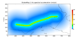
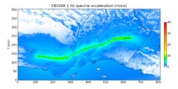
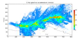
Ground motion estimates for the M8 rupture can be produced using empirically derived attenuation relationship (i.e. ShakeMap AR and Campbell and Bozorgnia 2008) or using full 3d wave propagation simulations such as M8. The wave propagation approach is more computationally expensive however this approach is expected to produce more accurate ground motion estimates. The following maps are intended to compare the results using these different approaches including alternative attenuation relationships. SCEC's OpenSHA software was used to create the attenuation-relationship maps. The M8 map is produced from M8 wave propagation simulation results.
PSHA Information
Earthquake Fault Zones
The Alquist-Priolo Earthquake Fault Zoning Act was passed in 1972 to mitigate the hazard of surface faulting to structures for human occupancy. This state law was a direct result of the 1971 San Fernando Earthquake, which was associated with extensive surface fault ruptures that damaged numerous homes, commercial buildings, and other structures. Surface rupture is the most easily avoided seismic hazard. What is the Alquist-Priolo Act?
The Alquist-Priolo Earthquake Fault Zoning Act's main purpose is to prevent the construction of buildings used for human occupancy on the surface trace of active faults. The Act only addresses the hazard of surface fault rupture and is not directed toward other earthquake hazards. The Seismic Hazards Mapping Act, passed in 1990, addresses non-surface fault rupture earthquake hazards, including liquefaction and seismically induced landslides. How does the law work?
The law requires the State Geologist to establish regulatory zones (known as Earthquake Fault Zones) around the surface traces of active faults and to issue appropriate maps. ["Earthquake Fault Zones" were called "Special Studies Zones" prior to January 1, 1994.] The maps are distributed to all affected cities, counties, and state agencies for their use in planning and controlling new or renewed construction. Local agencies must regulate most development projects within the zones. Projects include all land divisions and most structures for human occupancy. Single family wood-frame and steel-frame dwellings up to two stories not part of a development of four units or more are exempt. However, local agencies can be more restrictive than state law requires.
Before a project can be permitted, cities and counties must require a geologic investigation to demonstrate that proposed buildings will not be constructed across active faults. An evaluation and written report of a specific site must be prepared by a licensed geologist. If an active fault is found, a structure for human occupancy cannot be placed over the trace of the fault and must be set back from the fault (generally 50 feet). What is an earthquake fault zone?
Earthquake Fault Zones are regulatory zones around active faults. The zones are defined by turning points connected by straight lines. Most of the turning points are identified by roads, drainages, and other features on the ground. Earthquake Fault Zones are plotted on topographic maps at a scale of 1 inch equals 2,000 feet. The zones vary in width, but average about one-quarter mile wide. What is a fault?
A fault is a fracture in the crust of the earth along which rocks on one side have moved relative to those on the other side. Most faults are the result of repeated displacements over a long period of time. A fault trace is the line on the earth's surface defining the fault. For the purposes of the Act, an active fault is one that has ruptured in the last 11,000 years.


